
Make a donation
Gear up for your next adventure:
As an Amazon Associate, this site earns from qualifying purchases at no extra cost to you.
Tapfheim topographic map
Click on the map to display elevation.
Make a donation
Gear up for your next adventure:
As an Amazon Associate, this site earns from qualifying purchases at no extra cost to you.
Tapfheim
Am 30. Juni 2017 gab es nach der amtlichen Statistik 454 sozialversicherungspflichtig Beschäftigte am Arbeitsort und 1689 am Wohnort. Damit war die Zahl der Auspendler um 1235 höher als die Zahl der Einpendler. 25 Einwohner waren arbeitslos.
Make a donation
Gear up for your next adventure:
As an Amazon Associate, this site earns from qualifying purchases at no extra cost to you.
About this map
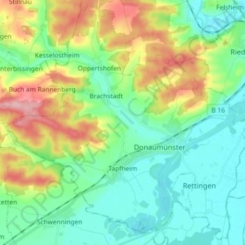
Name: Tapfheim topographic map, elevation, terrain.
Location: Tapfheim, Landkreis Donau-Ries, Bayern, 86660, Deutschland (48.64757 10.62099 48.72804 10.74864)
Average elevation: 443 m
Minimum elevation: 398 m
Maximum elevation: 545 m
Make a donation
Gear up for your next adventure:
As an Amazon Associate, this site earns from qualifying purchases at no extra cost to you.