
Make a donation
Gear up for your next adventure:
As an Amazon Associate, this site earns from qualifying purchases at no extra cost to you.
Tawang topographic map
Click on the map to display elevation.
Make a donation
Gear up for your next adventure:
As an Amazon Associate, this site earns from qualifying purchases at no extra cost to you.
Tawang
Tawang district, the basin of Tawang Chu, occupies an area of 2,172 square kilometres (839 sq mi),. The district is roughly located around latitude 27° 45’ N and longitude 90° 15’ E at the northwest extremity of Arunachal Pradesh. Elevations range between 6,000 and 22,000 feet (6,700 m), and inhabitants are found at lower altitude, where they enjoy a cool temperate climate.
Make a donation
Gear up for your next adventure:
As an Amazon Associate, this site earns from qualifying purchases at no extra cost to you.
About this map
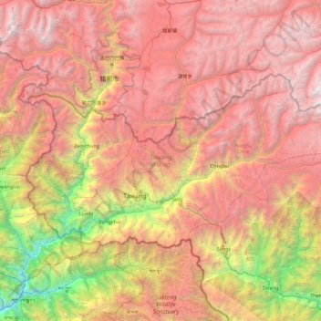
Name: Tawang topographic map, elevation, terrain.
Location: Tawang, Arunachal Pradesh, India (27.45982 91.56231 27.88775 92.45600)
Average elevation: 3,767 m
Minimum elevation: 798 m
Maximum elevation: 6,403 m
Make a donation
Gear up for your next adventure:
As an Amazon Associate, this site earns from qualifying purchases at no extra cost to you.
Other topographic maps
Click on a map to view its topography, its elevation and its terrain.
Itanagar
India > Arunachal Pradesh > Itanagar EAC
Itanagar is located at 27°06′N 93°37′E / 27.1°N 93.62°E / 27.1; 93.62. It has an average elevation of 320 metres.
Average elevation: 539 m