
Make a donation
Gear up for your next adventure:
As an Amazon Associate, this site earns from qualifying purchases at no extra cost to you.
Mandau/Mandava topographic map
Click on the map to display elevation.
Make a donation
Gear up for your next adventure:
As an Amazon Associate, this site earns from qualifying purchases at no extra cost to you.
About this map
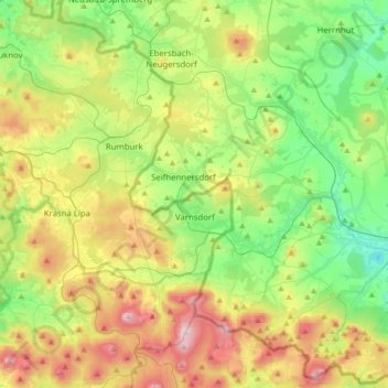
Name: Mandau/Mandava topographic map, elevation, terrain.
Location: Mandau/Mandava, Ústí nad Labem Region, Northwest, Czechia (50.88836 14.46258 50.96146 14.82588)
Average elevation: 411 m
Minimum elevation: 221 m
Maximum elevation: 779 m
Make a donation
Gear up for your next adventure:
As an Amazon Associate, this site earns from qualifying purchases at no extra cost to you.
Other topographic maps
Click on a map to view its topography, its elevation and its terrain.
Říp
Czechia > Northwest > Ústí nad Labem Region > Mnetěš
The name of the mountain is of pre-Slavic origin and probably comes from the Old-Germanic stem ríp- (elevation, hill), which has the Latin parallel in the word rípa (shore, slope, hillside). Some linguists also derive the origin of the name from the Illyrian-Thracian base.
Average elevation: 264 m
Brná
Czechia > Northwest > Ústí nad Labem Region > Ústí nad Labem
Among border points there are hills Kamenný vrch, Skřivánčí vrch and Modřín. There is Průčelský stream in Brná nad Labem and elevation is between 170 and 700 meters above sea level.
Average elevation: 366 m
Make a donation
Gear up for your next adventure:
As an Amazon Associate, this site earns from qualifying purchases at no extra cost to you.
Make a donation
Gear up for your next adventure:
As an Amazon Associate, this site earns from qualifying purchases at no extra cost to you.