Geolocate

Wano topographic map

Click on the map to display elevation.

About this map

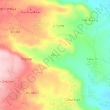
Name: Wano topographic map, elevation, terrain.

Location: Wano, Kuningan, West Java, Java, Indonesia (-6.93165 108.51625 -6.89165 108.55625)

Average elevation: 362 m

Minimum elevation: 223 m

Maximum elevation: 492 m

Other topographic maps

Click on a map to view its topography, its elevation and its terrain.

Gear up for your next adventure:

🏃Hydration Running Vest - Carry water and maps close to your body for speed
🔦UV Flashlight - Detect minerals or specific insects in the dark
🧤Rechargeable Heated Gloves - Extreme warmth for Canadian winter expeditions
Camping Essentials - All-in-one gear for a comfortable camping trip
🚲Heavy Duty Bike Lock - Secure your bike at the trailhead or during stops

As an Amazon Associate, this site earns from qualifying purchases at no extra cost to you.