Geolocate

Bingham topographic map

Click on the map to display elevation.

About this map

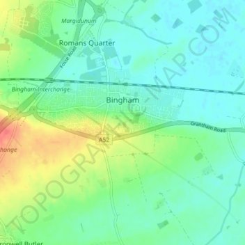
Name: Bingham topographic map, elevation, terrain.

Location: Bingham, Rushcliffe, Nottinghamshire, East Midlands, England, United Kingdom (52.92835 -0.98581 52.96686 -0.91605)

Average elevation: 33 m

Minimum elevation: 18 m

Maximum elevation: 69 m

Other topographic maps

Click on a map to view its topography, its elevation and its terrain.

Gear up for your next adventure:

🥫Freeze-Dried Meals - Lightweight, high-calorie nutrition for multi-day treks
🥾Lightweight Hiking Shoes - Comfortable shoes for day hikes
🥾Trail Hiking Boots - Supportive boots for rough trails
🥾All-Terrain Hiking Boots - Versatile boots for varied hiking conditions
🛰️Satellite Messenger - Emergency communication for areas with no cell service

As an Amazon Associate, this site earns from qualifying purchases at no extra cost to you.