
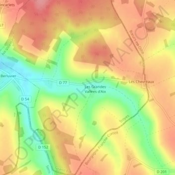
Les Grandes Vallées topographic map
Interactive map
Click on the map to display elevation.
About this map
Name: Les Grandes Vallées topographic map, elevation, terrain.
Average elevation: 216 m
Minimum elevation: 163 m
Maximum elevation: 253 m
Other topographic maps
Click on a map to view its topography, its elevation and its terrain.
L Ermitage
France > Grand Est > Aix-Villemaur-Pâlis
L Ermitage, Palis, Aix-Villemaur-Pâlis, Troyes, Aube, Grand Est, France métropolitaine, 10190, France
Average elevation: 240 m
La Rue des Vignes
France > Grand Est > Aix-Villemaur-Pâlis
La Rue des Vignes, Palis, Aix-Villemaur-Pâlis, Troyes, Aube, Grand Est, France métropolitaine, 10190, France
Average elevation: 210 m