
Przemyśl topographic map
Interactive map
Click on the map to display elevation.
About this map
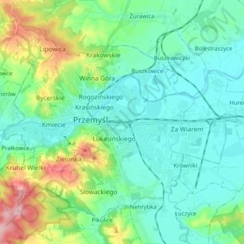
Name: Przemyśl topographic map, elevation, terrain.
Location: Przemyśl, Subcarpathian Voivodeship, Poland (49.74646 22.71306 49.82064 22.85544)
Average elevation: 237 m
Minimum elevation: 188 m
Maximum elevation: 401 m
Other topographic maps
Click on a map to view its topography, its elevation and its terrain.
P-16
Poland > Subcarpathian Voivodeship > Przemyśl
P-16, Wysokie Góry, Przemysława, Osiedle Przemysława, Przemyśl, Subcarpathian Voivodeship, 37-700, Poland
Average elevation: 238 m