
Make a donation
Gear up for your next adventure:
As an Amazon Associate, this site earns from qualifying purchases at no extra cost to you.
Ayeneux topographic map
Click on the map to display elevation.
Make a donation
Gear up for your next adventure:
As an Amazon Associate, this site earns from qualifying purchases at no extra cost to you.
Ayeneux
Ayeneux ligt op het Plateau van Herve, op een hoogte van ongeveer 240 meter. Ten noordoosten van de kom stroomt de Ruisseau des Marais in zuidelijke richting naar de Magne. De omgeving van Ayeneux bestaat voornamelijk uit landbouwgebied.
Make a donation
Gear up for your next adventure:
As an Amazon Associate, this site earns from qualifying purchases at no extra cost to you.
About this map
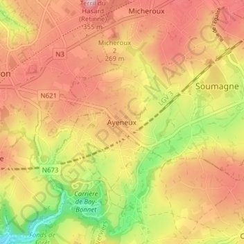
Name: Ayeneux topographic map, elevation, terrain.
Location: Ayeneux, Soumagne, Luik, Wallonië, 4630, België (50.58881 5.69527 50.62881 5.73527)
Average elevation: 227 m
Minimum elevation: 106 m
Maximum elevation: 312 m
Make a donation
Gear up for your next adventure:
As an Amazon Associate, this site earns from qualifying purchases at no extra cost to you.