
Make a donation
Gear up for your next adventure:
As an Amazon Associate, this site earns from qualifying purchases at no extra cost to you.
Alpuech topographic map
Click on the map to display elevation.
Make a donation
Gear up for your next adventure:
As an Amazon Associate, this site earns from qualifying purchases at no extra cost to you.
About this map
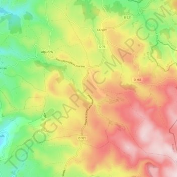
Name: Alpuech topographic map, elevation, terrain.
Average elevation: 1,104 m
Minimum elevation: 899 m
Maximum elevation: 1,307 m
Make a donation
Gear up for your next adventure:
As an Amazon Associate, this site earns from qualifying purchases at no extra cost to you.
Other topographic maps
Click on a map to view its topography, its elevation and its terrain.
Bedet
France > Occitanie > Aveyron > Argences en Aubrac > Sainte-Geneviève-sur-Argence
Average elevation: 748 m
Make a donation
Gear up for your next adventure:
As an Amazon Associate, this site earns from qualifying purchases at no extra cost to you.
Saint-Yves
France > Occitanie > Aveyron > Argences en Aubrac > Sainte-Geneviève-sur-Argence > Saint-Yves
Average elevation: 754 m