
Make a donation
Gear up for your next adventure:
As an Amazon Associate, this site earns from qualifying purchases at no extra cost to you.
Lago Xolotlán topographic map
Click on the map to display elevation.
Make a donation
Gear up for your next adventure:
As an Amazon Associate, this site earns from qualifying purchases at no extra cost to you.
Lago Xolotlán
El lago Xolotlán o lago de Managua está localizado en el oeste de Nicaragua. Está en la región de las tierras bajas del país. Es el segundo lago más grande del país y de América central, con una extensión de 1049 km², una longitud de 65 km y una anchura máxima de 58 km. La profundidad máxima es de 20 m y la media de 9,5 m. Está localizado a una altitud de 39 m s. n. m. La ciudad de Managua se asienta en su costa sureste.
Make a donation
Gear up for your next adventure:
As an Amazon Associate, this site earns from qualifying purchases at no extra cost to you.
About this map
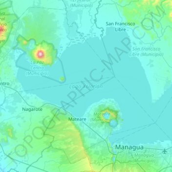
Name: Lago Xolotlán topographic map, elevation, terrain.
Location: Lago Xolotlán, León, 11000, Nicaragua (12.15657 -86.61169 12.50602 -86.09945)
Average elevation: 100 m
Minimum elevation: 22 m
Maximum elevation: 1,258 m
Make a donation
Gear up for your next adventure:
As an Amazon Associate, this site earns from qualifying purchases at no extra cost to you.
Other topographic maps
Click on a map to view its topography, its elevation and its terrain.