
Santa Leonor topographic map
Interactive map
Click on the map to display elevation.
About this map
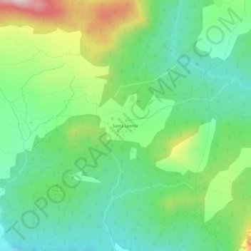
Name: Santa Leonor topographic map, elevation, terrain.
Location: Santa Leonor, Cebreros, Ávila, Castilla y León, España (40.41245 -4.40739 40.45245 -4.36739)
Average elevation: 718 m
Minimum elevation: 581 m
Maximum elevation: 1,005 m
Other topographic maps
Click on a map to view its topography, its elevation and its terrain.
Cerro de la Estrella
España > Castilla y León > Cebreros
Cerro de la Estrella, Cebreros, Ávila, Castilla y León, 05260, España
Average elevation: 1,006 m