Geolocate

Marne topographic map

Click on the map to display elevation.

About this map

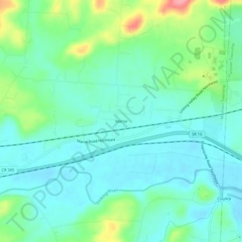
Name: Marne topographic map, elevation, terrain.

Location: Marne, Licking County, Ohio, United States (40.05118 -82.32932 40.09118 -82.28932)

Average elevation: 258 m

Minimum elevation: 233 m

Maximum elevation: 333 m

Other topographic maps

Click on a map to view its topography, its elevation and its terrain.

Hartford

United States > Ohio > Licking County

Average elevation: 353 m

Granville South

United States > Ohio > Licking County

Average elevation: 314 m

Granville Township

United States > Ohio > Licking County

Average elevation: 317 m

Pataskala

United States > Ohio > Licking County

Average elevation: 332 m

Harrison Township

United States > Ohio > Licking County

Average elevation: 320 m

Madison Township

United States > Ohio > Licking County

Average elevation: 273 m

Gratiot

United States > Ohio > Licking County

Average elevation: 296 m

Mary Ann Township

United States > Ohio > Licking County

Average elevation: 303 m

Etna Township

United States > Ohio > Licking County

Average elevation: 311 m

Alexandria

United States > Ohio > Licking County

Average elevation: 299 m

Newark Earthworks

United States > Ohio > Licking County > Heath

Average elevation: 262 m

McKean Township

United States > Ohio > Licking County

Average elevation: 345 m

Gear up for your next adventure:

🥫Freeze-Dried Meals - Lightweight, high-calorie nutrition for multi-day treks
🛰️Satellite Messenger - Emergency communication for areas with no cell service
🧥Waterproof Pants - Keep dry during rainy hiking conditions
🦶Hiking Shoe Insoles - Added support for high arches and long days on feet
🎒Backpack Rain Cover - External shield to keep your entire pack dry

As an Amazon Associate, this site earns from qualifying purchases at no extra cost to you.