
Make a donation
Gear up for your next adventure:
As an Amazon Associate, this site earns from qualifying purchases at no extra cost to you.
Bad Breisig topographic map
Click on the map to display elevation.
Make a donation
Gear up for your next adventure:
As an Amazon Associate, this site earns from qualifying purchases at no extra cost to you.
About this map
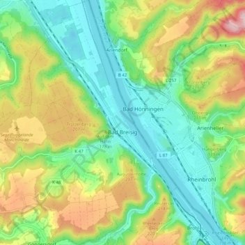
Name: Bad Breisig topographic map, elevation, terrain.
Average elevation: 143 m
Minimum elevation: 48 m
Maximum elevation: 313 m
Make a donation
Gear up for your next adventure:
As an Amazon Associate, this site earns from qualifying purchases at no extra cost to you.
Other topographic maps
Click on a map to view its topography, its elevation and its terrain.
Laacher See
Deutschland > Rheinland-Pfalz > Landkreis Ahrweiler > Glees
Das geförderte vulkanische Material war vorwiegend von phonolithischem Typ, der nur in der dritten Phase einen zunehmend höheren Anteil an primitiverem mafischem Material enthielt. Über die Gesamtmenge des Materials herrscht Uneinigkeit. So ist von 6 km³ DRE entsprechend 16–20 km³ Lockermassen die Rede,…
Average elevation: 314 m
Rolandswerth
Deutschland > Rheinland-Pfalz > Landkreis Ahrweiler > Remagen
Rolandswerth erstreckt sich am linken Rheinufer zwischen Mehlem im Nordwesten und Rolandseck im Süden, zu denen entlang der Bundesstraße 9 ein fließender Übergang besteht. Die Ortschaft umfasst Höhenlagen zwischen 54 m ü. NHN und 105 m ü. NHN, wobei sie sich nach Süden deutlich verjüngt.…
Average elevation: 106 m