
Hout Bay topographic map
Interactive map
Click on the map to display elevation.
About this map
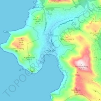
Name: Hout Bay topographic map, elevation, terrain.
Average elevation: 190 m
Minimum elevation: 0 m
Maximum elevation: 921 m
Other topographic maps
Click on a map to view its topography, its elevation and its terrain.
Bellville
South Africa > Western Cape > City of Cape Town
Bellville, City of Cape Town, Western Cape, South Africa
Average elevation: 115 m
Cape Town Ward 45
South Africa > Western Cape > City of Cape Town
Cape Town Ward 45, City of Cape Town, Western Cape, South Africa
Average elevation: 21 m