Geolocate

Helvoirt topographic map

Click on the map to display elevation.

About this map

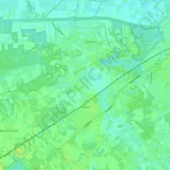
Name: Helvoirt topographic map, elevation, terrain.

Location: Helvoirt, Vught, North Brabant, Netherlands (51.61559 5.15445 51.66982 5.26709)

Average elevation: 7 m

Minimum elevation: 1 m

Maximum elevation: 14 m

Other topographic maps

Click on a map to view its topography, its elevation and its terrain.

Hout

Netherlands > North Brabant > Geldrop

Average elevation: 22 m

Eindhoven

Netherlands > North Brabant > Eindhoven

The villages and city that make up modern Eindhoven were originally built on sandy elevations between the Dommel, Gender and Tongelreep rivers. Beginning in the 19th century, the basins of the rivers themselves have also been used as housing land, resulting in occasional flooding in the city centre. Partly to…

Average elevation: 21 m

Gear up for your next adventure:

🥾Trekking Boots - Durable boots for long-distance trekking
🧢Outdoor Visor - Breathable visor for sunny hikes
🧰Emergency Multi-Tool - Compact multi-tool for outdoor survival
🛶Canoe Life Vest - Safety vest for water sports
🔦LED Headlamp - Hands-free lighting for early morning starts or late finishes

As an Amazon Associate, this site earns from qualifying purchases at no extra cost to you.