
Make a donation
Gear up for your next adventure:
As an Amazon Associate, this site earns from qualifying purchases at no extra cost to you.
Localidad San Cristóbal topographic map
Click on the map to display elevation.
Make a donation
Gear up for your next adventure:
As an Amazon Associate, this site earns from qualifying purchases at no extra cost to you.
About this map
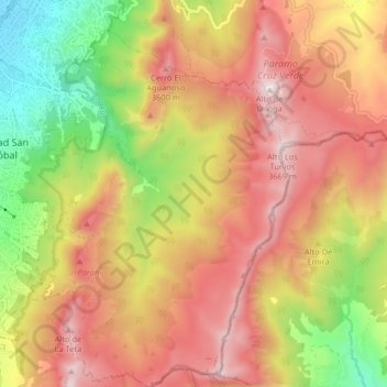
Name: Localidad San Cristóbal topographic map, elevation, terrain.
Average elevation: 2,863 m
Minimum elevation: 2,518 m
Maximum elevation: 3,628 m
Make a donation
Gear up for your next adventure:
As an Amazon Associate, this site earns from qualifying purchases at no extra cost to you.
Other topographic maps
Click on a map to view its topography, its elevation and its terrain.
Parque Metropolitano Simón Bolívar
Colombia > Bogotá, Distrito Capital > Bogotá
Average elevation: 2,552 m
Make a donation
Gear up for your next adventure:
As an Amazon Associate, this site earns from qualifying purchases at no extra cost to you.
Meandro del rio Tunjuelo/Humedal media luna o Tingua Azul
Colombia > Bogotá, Distrito Capital > Bogotá
Average elevation: 2,556 m
Make a donation
Gear up for your next adventure:
As an Amazon Associate, this site earns from qualifying purchases at no extra cost to you.
Meandro del rio Tunjuelo/Humedal media luna o Tingua Azul
Colombia > Bogotá, Distrito Capital > Bogotá
Average elevation: 2,556 m
Make a donation
Gear up for your next adventure:
As an Amazon Associate, this site earns from qualifying purchases at no extra cost to you.