Geolocate

Macchie topographic map

Click on the map to display elevation.

About this map

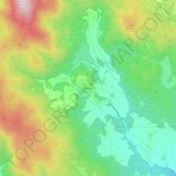
Name: Macchie topographic map, elevation, terrain.

Location: Macchie, Amelia, Terni, Umbria, 05022, Italy (42.57874 12.34544 42.61874 12.38544)

Average elevation: 521 m

Minimum elevation: 324 m

Maximum elevation: 826 m

Gear up for your next adventure:

🦯Trekking Poles - Reduced impact on joints for steep topographic climbs
💡Solar Camping Lamp - Eco-friendly lighting for campsites
🥾Approach Boots - Comfortable boots for hiking and climbing approaches
🔭Compact Monocular - One-handed bird watching and trail spotting
🥾Waterproof Trail Shoes - Shoes designed to handle wet terrain

As an Amazon Associate, this site earns from qualifying purchases at no extra cost to you.