Geolocate

Haynes topographic map

Click on the map to display elevation.

About this map

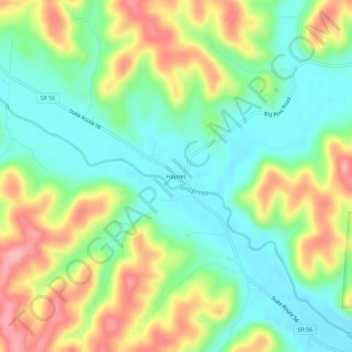
Name: Haynes topographic map, elevation, terrain.

Location: Haynes, Hocking County, Ohio, United States (39.41479 -82.69906 39.45479 -82.65906)

Average elevation: 255 m

Minimum elevation: 204 m

Maximum elevation: 335 m

Other topographic maps

Click on a map to view its topography, its elevation and its terrain.

Murray City

United States > Ohio > Hocking County

Average elevation: 257 m

Rose Lake

United States > Ohio > Hocking County

Average elevation: 295 m

Logan

United States > Ohio > Hocking County

Average elevation: 254 m

Rose Lake Dam

United States > Ohio > Hocking County

Average elevation: 297 m

Gear up for your next adventure:

👟Leg Gaiters - Keep debris, mud, and snow out of your boots
🧢Sun Protection Cap - Breathable cap to protect from sun exposure
🕶️Polarized Sunglasses - Protect your eyes with durable polarized lenses
❄️Traction Ice Cleats - Slip-on spikes for icy trails and winter hiking
🔦LED Flashlight - Powerful and long-lasting flashlight for camping and emergencies

As an Amazon Associate, this site earns from qualifying purchases at no extra cost to you.