
Make a donation
Gear up for your next adventure:
As an Amazon Associate, this site earns from qualifying purchases at no extra cost to you.
Arantiones topographic map
Click on the map to display elevation.
Make a donation
Gear up for your next adventure:
As an Amazon Associate, this site earns from qualifying purchases at no extra cost to you.
Arantiones
Arantiones es una localidad del municipio de Valderredible (Cantabria, España). Está localizada a 943 m s. n. m. de altitud, y dista 3,2 km de la capital municipal, Polientes. En el año 2012 contaba con una población de 10 habitantes (INE).
Make a donation
Gear up for your next adventure:
As an Amazon Associate, this site earns from qualifying purchases at no extra cost to you.
About this map
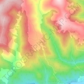
Name: Arantiones topographic map, elevation, terrain.
Location: Arantiones, Valderredible, Cantabria, 39220, España (42.80374 -3.99012 42.84374 -3.95012)
Average elevation: 905 m
Minimum elevation: 696 m
Maximum elevation: 1,068 m
Make a donation
Gear up for your next adventure:
As an Amazon Associate, this site earns from qualifying purchases at no extra cost to you.
Other topographic maps
Click on a map to view its topography, its elevation and its terrain.