Geolocate

Jump topographic map

Click on the map to display elevation.

About this map

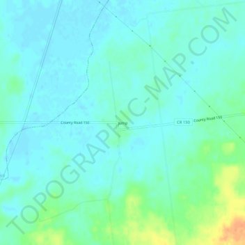
Name: Jump topographic map, elevation, terrain.

Location: Jump, McDonald Township, Hardin County, Ohio, United States (40.59588 -83.81438 40.63588 -83.77438)

Average elevation: 303 m

Minimum elevation: 294 m

Maximum elevation: 331 m

Other topographic maps

Click on a map to view its topography, its elevation and its terrain.

Ada

United States > Ohio > Hardin County

Average elevation: 293 m

Alger

United States > Ohio > Hardin County

Average elevation: 304 m

Dunkirk

United States > Ohio > Hardin County

Average elevation: 287 m

Forest

United States > Ohio > Hardin County

Average elevation: 283 m

McGuffey

United States > Ohio > Hardin County

Average elevation: 296 m

Mount Victory

United States > Ohio > Hardin County

Average elevation: 317 m

Patterson

United States > Ohio > Hardin County

Average elevation: 281 m

Ridgeway

United States > Ohio > Hardin County

Average elevation: 323 m

Buck Township

United States > Ohio > Hardin County

Average elevation: 303 m

Gear up for your next adventure:

🥾Durable Hiking Shoes - Long-lasting shoes for frequent hiking
🥾Waterproof Trail Shoes - Shoes designed to handle wet terrain
👟Sport Hiking Sandals - Breathable footwear for water crossings and camp rest
🧢Sun Protection Cap - Breathable cap to protect from sun exposure
🩹Compact First Aid Kit - Pre-packed essentials for common trail injuries

As an Amazon Associate, this site earns from qualifying purchases at no extra cost to you.