
Thank you for supporting this site ❤️
Make a donation
Make a donation
Gear up for your next adventure:
As an Amazon Associate, this site earns from qualifying purchases at no extra cost to you.
Offenhausen topographic map
Click on the map to display elevation.
Thank you for supporting this site ❤️
Make a donation
Make a donation
Gear up for your next adventure:
As an Amazon Associate, this site earns from qualifying purchases at no extra cost to you.
About this map
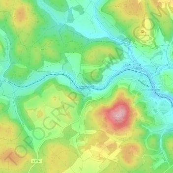
Name: Offenhausen topographic map, elevation, terrain.
Average elevation: 724 m
Minimum elevation: 653 m
Maximum elevation: 841 m
Thank you for supporting this site ❤️
Make a donation
Make a donation
Gear up for your next adventure:
As an Amazon Associate, this site earns from qualifying purchases at no extra cost to you.
Other topographic maps
Click on a map to view its topography, its elevation and its terrain.
Biosphärengebiet Schwäbische Alb (Kernzone)
Deutschland > Baden-Württemberg > Landkreis Reutlingen > Gomadingen
Average elevation: 649 m