
Make a donation
Gear up for your next adventure:
As an Amazon Associate, this site earns from qualifying purchases at no extra cost to you.
Banks Peninsula topographic map
Click on the map to display elevation.
Make a donation
Gear up for your next adventure:
As an Amazon Associate, this site earns from qualifying purchases at no extra cost to you.
About this map
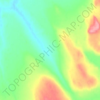
Name: Banks Peninsula topographic map, elevation, terrain.
Location: Banks Peninsula, Kitikmeot Region, Nunavut, Canada (67.21569 -108.28130 67.21579 -108.28120)
Average elevation: 89 m
Minimum elevation: 47 m
Maximum elevation: 162 m
Make a donation
Gear up for your next adventure:
As an Amazon Associate, this site earns from qualifying purchases at no extra cost to you.
Other topographic maps
Click on a map to view its topography, its elevation and its terrain.
Iqaluit
Canada > Nunavut > ᐃᖃᓗᐃᑦ > Iqaluit
Iqaluit has a tundra climate (Köppen: ET) typical of the Arctic region, although it is well outside the Arctic Circle. The city features very long, cold winters and brief, cool summers. Average monthly temperatures are below freezing for eight months of the year. Iqaluit averages just over 400 mm (16 in) of…
Average elevation: 50 m