Geolocate

Dagua topographic map

Click on the map to display elevation.

About this map

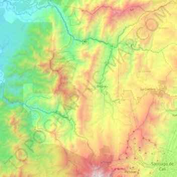
Name: Dagua topographic map, elevation, terrain.

Location: Dagua, Sur, Valle del Cauca, RAP Pacífico, 760529, Colombia (3.42400 -76.88583 3.87871 -76.56375)

Average elevation: 1,218 m

Minimum elevation: 21 m

Maximum elevation: 3,208 m

Other topographic maps

Click on a map to view its topography, its elevation and its terrain.

Río La Paila

Colombia > Valle del Cauca > Sevilla > Zarzal

Average elevation: 1,017 m

Charco Las Pilas

Colombia > Valle del Cauca > Cali

Average elevation: 1,197 m

Villa Gorgona

Colombia > Valle del Cauca > Candelaria

Average elevation: 966 m

Río Bolo

Colombia > Valle del Cauca > Pradera

Average elevation: 1,317 m

Malpelo Island

Colombia > Valle del Cauca

Average elevation: 9 m

Quebrada Nueva

Colombia > Valle del Cauca > Quebrada Nueva

Average elevation: 1,111 m

El Billar

Colombia > Valle del Cauca > Ansermanuevo > El Billar

Average elevation: 1,697 m

Loboguerrero

Colombia > Valle del Cauca > Dagua

Average elevation: 865 m

Gear up for your next adventure:

🥾Waterproof Trail Shoes - Shoes designed to handle wet terrain
Camping Tent - Weather-resistant tents suitable for 2 to 6 people
🧥Ultralight Puffy Jacket - Maximum warmth that packs down to the size of an orange
🪑Insulated Seat Pad - Protect your seat from cold rocks and wet logs
🚲Heavy Duty Bike Lock - Secure your bike at the trailhead or during stops

As an Amazon Associate, this site earns from qualifying purchases at no extra cost to you.