Geolocate

Unionville topographic map

Click on the map to display elevation.

About this map

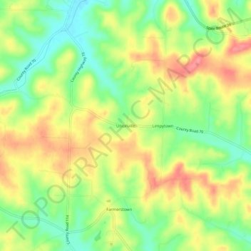
Name: Unionville topographic map, elevation, terrain.

Location: Unionville, Holmes County, Ohio, 44687, United States (40.48062 -81.74430 40.52062 -81.70430)

Average elevation: 343 m

Minimum elevation: 302 m

Maximum elevation: 384 m

Other topographic maps

Click on a map to view its topography, its elevation and its terrain.

Lake Buckhorn

United States > Ohio > Holmes County > Clark

Average elevation: 300 m

Holmesville

United States > Ohio > Holmes County

Average elevation: 262 m

Nashville

United States > Ohio > Holmes County

Average elevation: 363 m

Gear up for your next adventure:

🎒Hiking Daypack - Lightweight and durable backpacks for day trips and excursions
🪑Ultralight Camping Stool - Compact seating for rest stops during long hikes
🧢Beanie Hat - Keep your head warm in cold weather
🦟Insect Repellent - Keep mosquitoes and black flies away in wooded areas
🥾Waterproof Hiking Boots - Boots keeping your feet dry in wet conditions

As an Amazon Associate, this site earns from qualifying purchases at no extra cost to you.