
Tableland topographic map
Click on the map to display elevation.
About this map
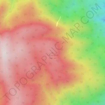
Name: Tableland topographic map, elevation, terrain.
Location: Tableland, Tasman District, Tasman, New Zealand (-40.90247 172.94681 -40.90237 172.94691)
Average elevation: 779 m
Minimum elevation: 375 m
Maximum elevation: 1,027 m
Other topographic maps
Click on a map to view its topography, its elevation and its terrain.
Brown River
New Zealand > Tasman > Tasman District
The source of the Brown River is near Brown Hill (elevation 1,104 metres or 3,622 feet) and the river flows north from the ridgeline adjacent to this hill. The Heaphy Track is on the south side of that ridgeline, with the river's source roughly halfway between Aorere Shelter and Flanagans Corner (the track's…
Average elevation: 625 m