Geolocate

Sorrento topographic map

Click on the map to display elevation.

About this map

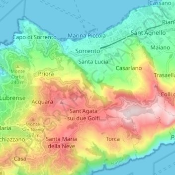
Name: Sorrento topographic map, elevation, terrain.

Location: Sorrento, Napoli, Campania, 80067, Italy (40.59454 14.34642 40.63452 14.41095)

Average elevation: 196 m

Minimum elevation: 0 m

Maximum elevation: 529 m

Other topographic maps

Click on a map to view its topography, its elevation and its terrain.

Monte Muto

Italy > Campania > Napoli > Gragnano

Average elevation: 444 m

Naples

Italy > Campania > Napoli > Naples

In 1755, the Duke of Noja commissioned an accurate topographic map of Naples, later known as the Map of the Duke of Nojo, employing rigorous surveying accuracy and becoming an important urban planning tool for Naples.

Average elevation: 58 m

Gear up for your next adventure:

🧊Portable Cooler - Keep food and drinks cold during outdoor adventures
🧥Packable Rain Jacket - Breathable waterproof layer for unpredictable weather
🧢Sun Protection Cap - Breathable cap to protect from sun exposure
🕶️Polarized Sunglasses - Reduces glare from snow and water at high elevations
🥾Light Trekking Boots - Supportive boots for multi-day treks

As an Amazon Associate, this site earns from qualifying purchases at no extra cost to you.