
Bezirk Villach-Land topographic map
Interactive map
Click on the map to display elevation.
About this map
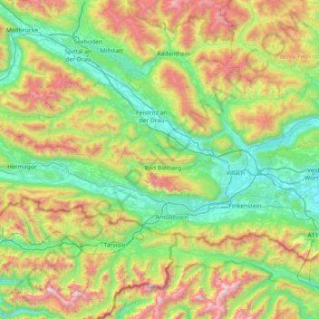
Name: Bezirk Villach-Land topographic map, elevation, terrain.
Location: Bezirk Villach-Land, Carinthie, Autriche (46.47882 13.40881 46.79462 14.12443)
Average elevation: 1,132 m
Minimum elevation: 456 m
Maximum elevation: 2,706 m
Other topographic maps
Click on a map to view its topography, its elevation and its terrain.
Bezirk Spittal an der Drau
Bezirk Spittal an der Drau, Carinthie, Autriche
Average elevation: 1,520 m
Mitterberg
Autriche > Carinthie > Bezirk Spittal an der Drau > Reißeck > Zandlach
Mitterberg, Zandlach, Reißeck, Bezirk Spittal an der Drau, Carinthie, 9815, Autriche
Average elevation: 1,062 m
Jenig
Autriche > Carinthie > Bezirk Hermagor > Hermagor-Pressegger See
Jenig, Hermagor-Pressegger See, Bezirk Hermagor, Carinthie, 9631, Autriche
Average elevation: 769 m
Niederdorf
Autriche > Carinthie > Bezirk Klagenfurt-Land
Niederdorf, Ebenthal in Kärnten, Bezirk Klagenfurt-Land, Carinthie, 9065, Autriche
Average elevation: 427 m
Hochosterwitz
Autriche > Carinthie > Bezirk Sankt Veit an der Glan > Sankt Georgen am Längsee
Hochosterwitz, Sankt Georgen am Längsee, Bezirk Sankt Veit an der Glan, Carinthie, 9314, Autriche
Average elevation: 628 m
Nötsch
Autriche > Carinthie > Bezirk Villach-Land > Nötsch im Gailtal
Nötsch, Nötsch im Gailtal, Bezirk Villach-Land, Carinthie, 9611, Autriche
Average elevation: 717 m
Karnischer Hauptkamm
Karnischer Hauptkamm, Carinthie, Autriche
Average elevation: 1,437 m
Bannwald
Autriche > Carinthie > Bezirk Klagenfurt-Land > Pörtschach am Wörther See
Bannwald, Pörtschach am Wörther See, Bezirk Klagenfurt-Land, Carinthie, 9210, Autriche
Average elevation: 541 m
Neufeld
Autriche > Carinthie > Bezirk Villach-Land > Finkenstein am Faaker See > Techanting
Neufeld, Techanting, Finkenstein am Faaker See, Bezirk Villach-Land, Carinthie, 9584, Autriche
Average elevation: 579 m
Ebenthal in Kärnten
Autriche > Carinthie > Ebenthal in Kärnten
Ebenthal in Kärnten, Bezirk Klagenfurt-Land, Carinthie, 9065, Autriche
Average elevation: 530 m
Karnburg
Autriche > Carinthie > Bezirk Klagenfurt-Land > Karnburg
Karnburg, Maria Saal, Bezirk Klagenfurt-Land, Carinthie, 9063, Autriche
Average elevation: 540 m
Hermagor-Pressegger See
Autriche > Carinthie > Bezirk Hermagor > Hermagor-Pressegger See
Hermagor-Pressegger See, Bezirk Hermagor, Carinthie, Autriche
Average elevation: 1,167 m
Oberdorf
Autriche > Carinthie > Bezirk Spittal an der Drau > Spittal an der Drau
Oberdorf, Spittal an der Drau, Bezirk Spittal an der Drau, Carinthie, 9800, Autriche
Average elevation: 608 m
Dert
Autriche > Carinthie > Bezirk Villach-Land > Hohenthurn
Dert, Hohenthurn, Bezirk Villach-Land, Carinthie, 9613, Autriche
Average elevation: 579 m
Malta
Autriche > Carinthie > Bezirk Spittal an der Drau
Malta, Bezirk Spittal an der Drau, Carinthie, 9854, Autriche
Average elevation: 1,724 m
Maria Saal
Autriche > Carinthie > Maria Saal
Maria Saal, Bezirk Klagenfurt-Land, Carinthie, 9063, Autriche
Average elevation: 541 m
Oschenitzen
Autriche > Carinthie > Bezirk Völkermarkt > Völkermarkt > Oschenitzen
Oschenitzen, Völkermarkt, Bezirk Völkermarkt, Carinthie, 9100, Autriche
Average elevation: 501 m
Bad Bleiberg
Autriche > Carinthie > Bad Bleiberg
Bad Bleiberg, Bezirk Villach-Land, Carinthie, 9530, Autriche
Average elevation: 911 m
Wörthersee
Autriche > Carinthie > Techelsberg am Wörther See
Wörthersee, Saag, Techelsberg am Wörther See, Klagenfurt-Land, Carinthie, 9212, Autriche
Average elevation: 619 m
Hochstuhl / Stol
Autriche > Carinthie > Bezirk Klagenfurt-Land > Feistritz im Rosental
Hochstuhl / Stol, Feistritz im Rosental, Bezirk Klagenfurt-Land, Carinthie, Autriche
Average elevation: 1,690 m
Sankt Veit an der Glan
Autriche > Carinthie > Bezirk Sankt Veit an der Glan
Sankt Veit an der Glan, Bezirk Sankt Veit an der Glan, Carinthie, 9300, Autriche
Average elevation: 591 m
Kokra
Autriche > Carinthie > Arnoldstein
Kokra, Arnoldstein, Villach-Land, Carinthie, 9601, Autriche
Average elevation: 1,068 m
Spittal an der Drau
Autriche > Carinthie > Bezirk Spittal an der Drau
Spittal an der Drau, Bezirk Spittal an der Drau, Carinthie, 9800, Autriche
Average elevation: 969 m
Heiligenblut am Großglockner
Autriche > Carinthie > Heiligenblut am Großglockner
Heiligenblut am Großglockner, Spittal an der Drau, Carinthie, 9844, Autriche
Average elevation: 2,237 m
Feldkirchen in Kärnten
Feldkirchen in Kärnten, Bezirk Feldkirchen, Carinthie, 9560, Autriche
Average elevation: 721 m
Innerkrems
Autriche > Carinthie > Bezirk Spittal an der Drau > Krems in Kärnten
Innerkrems, Krems in Kärnten, Bezirk Spittal an der Drau, Carinthie, Autriche
Average elevation: 1,811 m
Wildhorn
Autriche > Carinthie > Rangersdorf
Wildhorn, Rangersdorf, Spittal an der Drau, Carinthie, Autriche
Average elevation: 2,209 m
Feldkirchen
Autriche > Carinthie > Feldkirchen in Kärnten
Feldkirchen, Feldkirchen in Kärnten, Feldkirchen, Carinthie, 9560, Autriche
Average elevation: 618 m
Ossiacher See
Autriche > Carinthie > Steindorf am Ossiacher See
Ossiacher See, Sankt-Urban-Weg, Steindorf am Ossiacher See, Feldkirchen, Carinthie, 9552, Autriche
Average elevation: 873 m
Klopeiner See
Autriche > Carinthie > Sankt Kanzian am Klopeiner See
Klopeiner See, Am See I, Sankt Kanzian am Klopeiner See, Völkermarkt, Carinthie, 9122, Autriche
Average elevation: 486 m
Zabersdorf
Autriche > Carinthie > Zabersdorf
Zabersdorf, Bezirk St. Veit an der Glan, Carinthie, 9341, Autriche
Average elevation: 882 m
Millstätter See
Autriche > Carinthie > Ferndorf
Millstätter See, Millstätter Seeradweg, Ferndorf, Villach-Land, Carinthie, 9702, Autriche
Average elevation: 896 m
Afritzer See
Autriche > Carinthie > Feld am See
Afritzer See, Millstätter Straße, Feld am See, Villach-Land, Carinthie, 9544, Autriche
Average elevation: 1,022 m
Faaker See
Autriche > Carinthie > Finkenstein am Faaker See
Faaker See, Halbinselstraße, Finkenstein am Faaker See, Villach-Land, Carinthie, 9584, Autriche
Average elevation: 572 m
Eisentratten
Autriche > Carinthie > Bezirk Spittal an der Drau > Krems in Kärnten
Eisentratten, Krems in Kärnten, Bezirk Spittal an der Drau, Carinthie, 9861, Autriche
Average elevation: 1,094 m