
Make a donation
Gear up for your next adventure:
As an Amazon Associate, this site earns from qualifying purchases at no extra cost to you.
Sanduru topographic map
Click on the map to display elevation.
Make a donation
Gear up for your next adventure:
As an Amazon Associate, this site earns from qualifying purchases at no extra cost to you.
Sanduru
Sanduru is located at 15°06′N 76°33′E / 15.1°N 76.55°E / 15.1; 76.55. It has an average elevation of 565 metres (1853 feet).
Make a donation
Gear up for your next adventure:
As an Amazon Associate, this site earns from qualifying purchases at no extra cost to you.
About this map
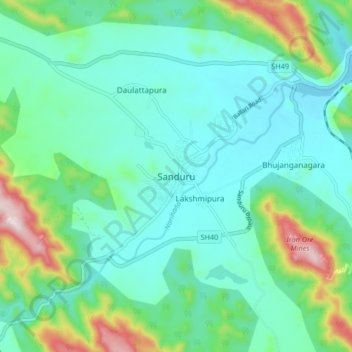
Name: Sanduru topographic map, elevation, terrain.
Location: Sanduru, Sanduru taluk, Ballari, Karnataka, 583119, India (15.04328 76.50341 15.12328 76.58341)
Average elevation: 647 m
Minimum elevation: 542 m
Maximum elevation: 1,001 m
Make a donation
Gear up for your next adventure:
As an Amazon Associate, this site earns from qualifying purchases at no extra cost to you.