Geolocate

Nedumbassery topographic map

Click on the map to display elevation.

About this map

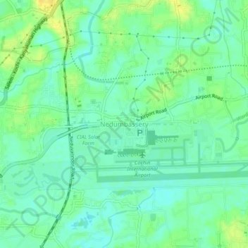
Name: Nedumbassery topographic map, elevation, terrain.

Location: Nedumbassery, Aluva, Ernakulam, Kerala, 683111, India (10.13952 76.36952 10.17952 76.40952)

Average elevation: 11 m

Minimum elevation: 1 m

Maximum elevation: 25 m

Other topographic maps

Click on a map to view its topography, its elevation and its terrain.

Mookkannoor

India > Kerala > Aluva > Ezhattumugham

Average elevation: 31 m

Thuravoor (Ernakulam)

India > Kerala > Aluva > Thuravoor

Average elevation: 22 m

Gear up for your next adventure:

🛶Canoe Life Vest - Safety vest for water sports
🥤Collapsible Travel Cup - Saves space and weight in your mess kit
🛏️Sleeping Bag - Warm and compact sleeping bags for outdoor camping
🔭Compact Monocular - One-handed bird watching and trail spotting
💡LED Camping Lantern - Illuminate your campsite with long-lasting lanterns

As an Amazon Associate, this site earns from qualifying purchases at no extra cost to you.