Geolocate

Songgokerto topographic map

Click on the map to display elevation.

About this map

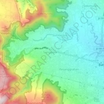
Name: Songgokerto topographic map, elevation, terrain.

Location: Songgokerto, Batu, East Java, Java, 65312, Indonesia (-7.88628 112.48743 -7.84628 112.52743)

Average elevation: 1,029 m

Minimum elevation: 856 m

Maximum elevation: 1,394 m

Other topographic maps

Click on a map to view its topography, its elevation and its terrain.

Alun-Alun Batu

Indonesia > East Java > Batu > Temas

Average elevation: 892 m

Alun-Alun Batu

Indonesia > East Java > Batu > Temas

Average elevation: 892 m

Gear up for your next adventure:

🧣Merino Neck Gaiter - Protects against wind, sun, and cold at high altitudes
🧭Orienteering Kit - Tools for map reading and navigation in the wild
🏃Hydration Running Vest - Carry water and maps close to your body for speed
💧Collapsible Water Bottle - Space-saving water bottle for outdoor activities
🧥Ultralight Puffy Jacket - Maximum warmth that packs down to the size of an orange

As an Amazon Associate, this site earns from qualifying purchases at no extra cost to you.