
Saunders Pond topographic map
Interactive map
Click on the map to display elevation.
About this map
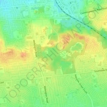
Name: Saunders Pond topographic map, elevation, terrain.
Average elevation: 273 m
Minimum elevation: 254 m
Maximum elevation: 289 m
Other topographic maps
Click on a map to view its topography, its elevation and its terrain.
Sherwood Forest
Sherwood Forest, Medway Heights, London, Southwestern Ontario, Ontario, N6G 2C3, Canada
Average elevation: 270 m
Stoneybrook
Stoneybrook, London, Southwestern Ontario, Ontario, N5X 1L8, Canada
Average elevation: 254 m
Gibbons Park
Gibbons Park, London, Southwestern Ontario, Ontario, Canada
Average elevation: 248 m
Shelbourne Park North
Shelbourne Park North, Glen Cairn Woods, London, Southwestern Ontario, Ontario, Canada
Average elevation: 262 m