
Vissoie topographic map
Interactive map
Click on the map to display elevation.
About this map
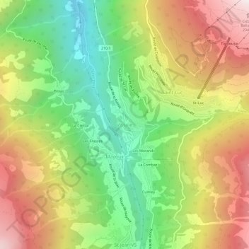
Name: Vissoie topographic map, elevation, terrain.
Location: Vissoie, Anniviers, Siders, Wallis, 3961, Schweiz (46.19532 7.56536 46.23532 7.60536)
Average elevation: 1,599 m
Minimum elevation: 891 m
Maximum elevation: 2,441 m
Other topographic maps
Click on a map to view its topography, its elevation and its terrain.