
Make a donation
Gear up for your next adventure:
As an Amazon Associate, this site earns from qualifying purchases at no extra cost to you.
Burg Landshut topographic map
Click on the map to display elevation.
Make a donation
Gear up for your next adventure:
As an Amazon Associate, this site earns from qualifying purchases at no extra cost to you.
Burg Landshut
Die Burg Landshut ist die Ruine einer Höhenburg in Bernkastel-Kues im rheinland-pfälzischen Landkreis Bernkastel-Wittlich.
Make a donation
Gear up for your next adventure:
As an Amazon Associate, this site earns from qualifying purchases at no extra cost to you.
About this map
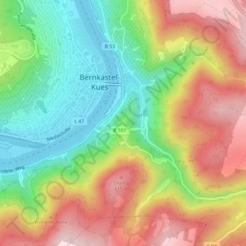
Name: Burg Landshut topographic map, elevation, terrain.
Average elevation: 261 m
Minimum elevation: 106 m
Maximum elevation: 439 m
Make a donation
Gear up for your next adventure:
As an Amazon Associate, this site earns from qualifying purchases at no extra cost to you.
Other topographic maps
Click on a map to view its topography, its elevation and its terrain.
Bernkasteler Doctor
Deutschland > Rheinland-Pfalz > Landkreis Bernkastel-Wittlich > Bernkastel-Kues
Average elevation: 258 m
Wehlen
Deutschland > Rheinland-Pfalz > Landkreis Bernkastel-Wittlich > Bernkastel-Kues
Average elevation: 221 m