
Make a donation
Gear up for your next adventure:
As an Amazon Associate, this site earns from qualifying purchases at no extra cost to you.
Allamuchy Township topographic map
Click on the map to display elevation.
Make a donation
Gear up for your next adventure:
As an Amazon Associate, this site earns from qualifying purchases at no extra cost to you.
About this map
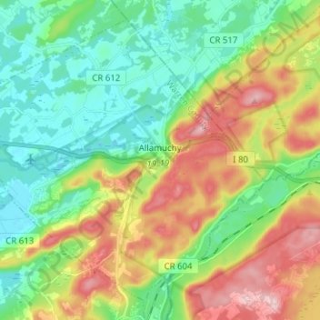
Name: Allamuchy Township topographic map, elevation, terrain.
Average elevation: 235 m
Minimum elevation: 153 m
Maximum elevation: 380 m
Make a donation
Gear up for your next adventure:
As an Amazon Associate, this site earns from qualifying purchases at no extra cost to you.
Other topographic maps
Click on a map to view its topography, its elevation and its terrain.
High Rock Mountain
United States > New Jersey > Warren County > White Township
Average elevation: 189 m
Make a donation
Gear up for your next adventure:
As an Amazon Associate, this site earns from qualifying purchases at no extra cost to you.
Mount Tammany
United States > New Jersey > Warren County > Knowlton Township
Hiking on Mount Tammany consists of two trails. The red dot trail and the blue dot trail. The red dot trail is 1.2 miles and the blue dot trail is 1.8 miles. Combining the two for one of NJ's most popular hikes is a 3 mile loop. There is a 1201 feet elevation change going up and down the mountain. Generally,…
Average elevation: 267 m
Make a donation
Gear up for your next adventure:
As an Amazon Associate, this site earns from qualifying purchases at no extra cost to you.
Make a donation
Gear up for your next adventure:
As an Amazon Associate, this site earns from qualifying purchases at no extra cost to you.