
Make a donation
Gear up for your next adventure:
As an Amazon Associate, this site earns from qualifying purchases at no extra cost to you.
Lügde topographic map
Click on the map to display elevation.
Make a donation
Gear up for your next adventure:
As an Amazon Associate, this site earns from qualifying purchases at no extra cost to you.
About this map
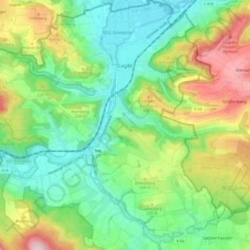
Name: Lügde topographic map, elevation, terrain.
Location: Lügde, Kreis Lippe, North Rhine-Westphalia, Germany (51.90982 9.18605 51.97769 9.28623)
Average elevation: 196 m
Minimum elevation: 89 m
Maximum elevation: 400 m
Make a donation
Gear up for your next adventure:
As an Amazon Associate, this site earns from qualifying purchases at no extra cost to you.
Other topographic maps
Click on a map to view its topography, its elevation and its terrain.
Horn-Bad Meinberg
Germany > North Rhine-Westphalia > Kreis Lippe
In the municipality are the two highest peaks of the Eggegebirge, the Lipp Velmerstot (441 m) and the Prussian Velmerstot with about (464 m) above sea level and the highest elevation of the Teutoburg forest, the Barnacken with (446 m). The deepest point of the metropolitan area is (125 m). Between the…
Average elevation: 240 m