
Thank you for supporting this site ❤️
Make a donation
Make a donation
Gear up for your next adventure:
As an Amazon Associate, this site earns from qualifying purchases at no extra cost to you.
Liegos topographic map
Click on the map to display elevation.
Thank you for supporting this site ❤️
Make a donation
Make a donation
Gear up for your next adventure:
As an Amazon Associate, this site earns from qualifying purchases at no extra cost to you.
Liegos
Situado en la orilla sur del río Esla y a una altitud de 1130 m s. n. m.
Thank you for supporting this site ❤️
Make a donation
Make a donation
Gear up for your next adventure:
As an Amazon Associate, this site earns from qualifying purchases at no extra cost to you.
About this map
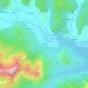
Name: Liegos topographic map, elevation, terrain.
Location: Liegos, Acebedo, León, Castilla y León, 24994, España (43.00451 -5.09592 43.04451 -5.05592)
Average elevation: 1,246 m
Minimum elevation: 1,088 m
Maximum elevation: 1,807 m
Thank you for supporting this site ❤️
Make a donation
Make a donation
Gear up for your next adventure:
As an Amazon Associate, this site earns from qualifying purchases at no extra cost to you.