
Make a donation
Gear up for your next adventure:
As an Amazon Associate, this site earns from qualifying purchases at no extra cost to you.
Gujan-Mestras topographic map
Click on the map to display elevation.
Make a donation
Gear up for your next adventure:
As an Amazon Associate, this site earns from qualifying purchases at no extra cost to you.
Gujan-Mestras
En 1803, les autres municipalités du département durent envoyer à la préfecture une étude sur la topographie, l’agriculture, l’industrie de sa commune, ainsi que sur l’état des habitants. À ce moment-là, cette étude regroupa deux quartiers que sont Gujan et Mestras sous le nom de commune Gujan. Cette étude ne prit pas en compte les rivalités qui existaient entre ces deux quartiers. Ainsi, jusqu'en 1936, le nom officiel fut simplement Gujan.
Make a donation
Gear up for your next adventure:
As an Amazon Associate, this site earns from qualifying purchases at no extra cost to you.
About this map
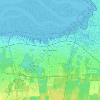
Name: Gujan-Mestras topographic map, elevation, terrain.
Average elevation: 5 m
Minimum elevation: -2 m
Maximum elevation: 17 m
Make a donation
Gear up for your next adventure:
As an Amazon Associate, this site earns from qualifying purchases at no extra cost to you.