Geolocate

Seidersberg topographic map

Click on the map to display elevation.

About this map

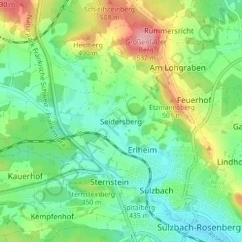
Name: Seidersberg topographic map, elevation, terrain.

Location: Seidersberg, Sulzbach-Rosenberg, Landkreis Amberg-Sulzbach, Bayern, 92237, Deutschland (49.49672 11.70714 49.53672 11.74714)

Average elevation: 439 m

Minimum elevation: 392 m

Maximum elevation: 534 m

Other topographic maps

Click on a map to view its topography, its elevation and its terrain.

Gear up for your next adventure:

🔭Compact Monocular - One-handed bird watching and trail spotting
🥾Trail Hiking Boots - Supportive boots for rough trails
🧤Rechargeable Heated Gloves - Extreme warmth for Canadian winter expeditions
Camping Tent - Weather-resistant tents suitable for 2 to 6 people
💧Collapsible Water Bottle - Space-saving water bottle for outdoor activities

As an Amazon Associate, this site earns from qualifying purchases at no extra cost to you.