Geolocate

Bangkinang topographic map

Click on the map to display elevation.

About this map

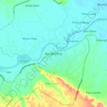
Name: Bangkinang topographic map, elevation, terrain.

Location: Bangkinang, Kampar Regency, Riau, Sumatra, 28411, Indonesia (0.30422 100.98147 0.38422 101.06147)

Average elevation: 50 m

Minimum elevation: 28 m

Maximum elevation: 136 m

Other topographic maps

Click on a map to view its topography, its elevation and its terrain.

Tapung Hulu

Indonesia > Riau > Kampar Regency

Average elevation: 37 m

Siak Hulu

Indonesia > Riau > Kampar Regency

Average elevation: 21 m

Sungai Kampar

Indonesia > Riau > Kampar Regency

Average elevation: 12 m

Kampar Regency

Indonesia > Riau > Kampar Regency

Average elevation: 161 m

Gear up for your next adventure:

🛏️Camping Sleeping Mat - Comfortable mats for sleeping outdoors
🧥Thermal Fleece Jacket - Versatile insulation for changing mountain temperatures
🥾Waterproof Hiking Shoes - Durable shoes for wet and rugged trails
🏕️Camping Hammock - Integrated protection for sleeping between trees
🗺️Topographic Maps - Detailed maps to explore trails, mountains, and wilderness areas

As an Amazon Associate, this site earns from qualifying purchases at no extra cost to you.