Geolocate

Holly Ridge topographic map

Click on the map to display elevation.

About this map

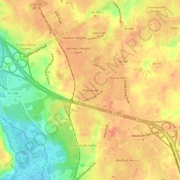
Name: Holly Ridge topographic map, elevation, terrain.

Location: Holly Ridge, Hanover County, Virginia, 23116, United States (37.61848 -77.41248 37.65848 -77.37248)

Average elevation: 51 m

Minimum elevation: 22 m

Maximum elevation: 66 m

Gear up for your next adventure:

🧦Merino Wool Socks - Moisture-wicking comfort for long-distance hiking
👟Leg Gaiters - Keep debris, mud, and snow out of your boots
🏕️Camping Hammock - Integrated protection for sleeping between trees
🥾Waterproof Trail Shoes - Shoes designed to handle wet terrain
🔪Outdoor Multitool - Versatile tool for repairs and food prep in the wild

As an Amazon Associate, this site earns from qualifying purchases at no extra cost to you.