Geolocate

Hawthorne topographic map

Click on the map to display elevation.

About this map

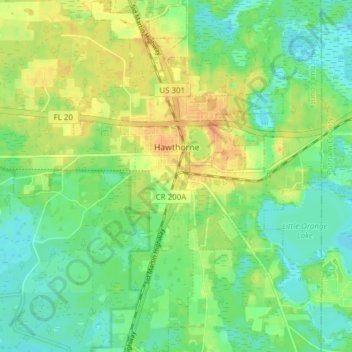
Name: Hawthorne topographic map, elevation, terrain.

Location: Hawthorne, Alachua County, Florida, United States (29.55305 -82.10951 29.61959 -82.05543)

Average elevation: 36 m

Minimum elevation: 20 m

Maximum elevation: 58 m

Other topographic maps

Click on a map to view its topography, its elevation and its terrain.

Earleton

United States > Florida > Alachua County

Average elevation: 46 m

Island Grove

United States > Florida > Alachua County

Average elevation: 18 m

Bland

United States > Florida > Alachua County

Average elevation: 44 m

Archer

United States > Florida > Alachua County > Archer

Average elevation: 25 m

Gear up for your next adventure:

🥾Hiking Gaiters - Protect legs and shoes from mud, snow, and debris
🛶Kayak Accessories - Essential gear for safe and fun kayaking adventures
🏃Hydration Running Vest - Carry water and maps close to your body for speed
🧢Hiking Hat - Sun-protective and breathable hats for long treks
🥾Lightweight Hiking Shoes - Comfortable shoes for day hikes

As an Amazon Associate, this site earns from qualifying purchases at no extra cost to you.