
Make a donation
Gear up for your next adventure:
As an Amazon Associate, this site earns from qualifying purchases at no extra cost to you.
Hafelekar topographic map
Click on the map to display elevation.
Make a donation
Gear up for your next adventure:
As an Amazon Associate, this site earns from qualifying purchases at no extra cost to you.
About this map
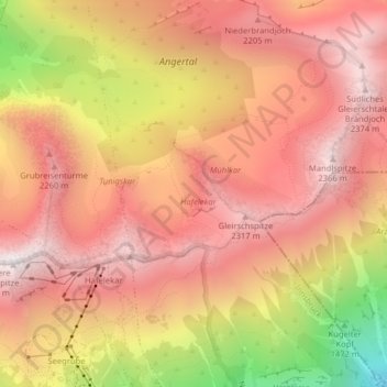
Name: Hafelekar topographic map, elevation, terrain.
Location: Hafelekar, Arzl, Innsbruck, Tirol, 6020, Österreich (47.31411 11.38712 47.32029 11.39526)
Average elevation: 1,964 m
Minimum elevation: 1,139 m
Maximum elevation: 2,395 m
Make a donation
Gear up for your next adventure:
As an Amazon Associate, this site earns from qualifying purchases at no extra cost to you.
Other topographic maps
Click on a map to view its topography, its elevation and its terrain.
Innsbruck
Österreich > Tirol > Innsbruck
Die Trinkwasserversorgung der Stadt erfolgt großteils aus der sogenannten Mühlauer Quelle, die im Inneren der Nordkette auf 1.140 Meter Seehöhe liegt und etwa zwischen 600 und 1.600 Liter Wasser pro Sekunde liefern. Die notwendigen Stollenanlagen zur Fassung der Quellen wurden in den Jahren 1942 bis 1953…
Average elevation: 611 m