
Make a donation
Gear up for your next adventure:
As an Amazon Associate, this site earns from qualifying purchases at no extra cost to you.
Montgomery Center topographic map
Click on the map to display elevation.
Make a donation
Gear up for your next adventure:
As an Amazon Associate, this site earns from qualifying purchases at no extra cost to you.
About this map
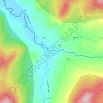
Name: Montgomery Center topographic map, elevation, terrain.
Average elevation: 269 m
Minimum elevation: 143 m
Maximum elevation: 487 m
Make a donation
Gear up for your next adventure:
As an Amazon Associate, this site earns from qualifying purchases at no extra cost to you.
Other topographic maps
Click on a map to view its topography, its elevation and its terrain.
Fletcher
United States > Vermont > Franklin County
Fletcher is located in southern Franklin County, bordered to the southeast by Lamoille County. According to the United States Census Bureau, the town has a total area of 38.0 square miles (98.4 km2), of which 37.7 square miles (97.7 km2) is land and 0.3 square miles (0.7 km2), or 0.71%, is water. The Lamoille…
Average elevation: 229 m
Missisquoi River
United States > Vermont > Franklin County
The Missisquoi River rises in western Orleans County, Vermont, northwest of Lowell, Vermont, at an altitude of 247 metres (810 ft). This source is located next to Route 58 and adjacent to Belvidere Mountain. This source proves to be the continuity of the Burgess Branch (coming from the southwest).
Average elevation: 277 m
Make a donation
Gear up for your next adventure:
As an Amazon Associate, this site earns from qualifying purchases at no extra cost to you.
Make a donation
Gear up for your next adventure:
As an Amazon Associate, this site earns from qualifying purchases at no extra cost to you.
Fletcher
United States > Vermont > Franklin County
Fletcher is located in southern Franklin County, bordered to the southeast by Lamoille County. According to the United States Census Bureau, the town has a total area of 38.0 square miles (98.4 km2), of which 37.7 square miles (97.7 km2) is land and 0.3 square miles (0.7 km2), or 0.71%, is water. The Lamoille…
Average elevation: 229 m
Make a donation
Gear up for your next adventure:
As an Amazon Associate, this site earns from qualifying purchases at no extra cost to you.
Make a donation
Gear up for your next adventure:
As an Amazon Associate, this site earns from qualifying purchases at no extra cost to you.