
Make a donation
Gear up for your next adventure:
As an Amazon Associate, this site earns from qualifying purchases at no extra cost to you.
Adelaide topographic map
Click on the map to display elevation.
Make a donation
Gear up for your next adventure:
As an Amazon Associate, this site earns from qualifying purchases at no extra cost to you.
Adelaide
South Australia was officially established as a British Province in England in February 1836. The first governor proclaimed the commencement of colonial government in South Australia on 28 December 1836, near The Old Gum Tree in what is now the suburb of Glenelg North. The event is commemorated in South Australia as Proclamation Day. The site of the colony's capital was surveyed and laid out by Colonel William Light, the first Surveyor-General of South Australia, with his own original, unique, topographically sensitive design. The city was named after Queen Adelaide.
Make a donation
Gear up for your next adventure:
As an Amazon Associate, this site earns from qualifying purchases at no extra cost to you.
About this map
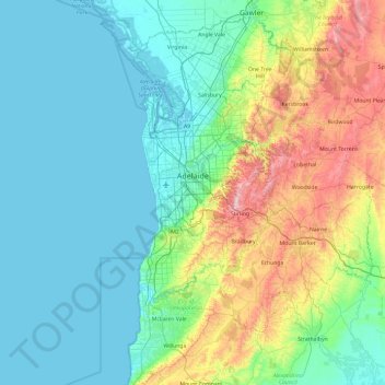
Name: Adelaide topographic map, elevation, terrain.
Average elevation: 146 m
Minimum elevation: -1 m
Maximum elevation: 709 m
Make a donation
Gear up for your next adventure:
As an Amazon Associate, this site earns from qualifying purchases at no extra cost to you.
Other topographic maps
Click on a map to view its topography, its elevation and its terrain.
Victoria Square
Australia > South Australia > Adelaide City Council > Adelaide
Average elevation: 47 m
Make a donation
Gear up for your next adventure:
As an Amazon Associate, this site earns from qualifying purchases at no extra cost to you.