
Make a donation
Gear up for your next adventure:
As an Amazon Associate, this site earns from qualifying purchases at no extra cost to you.
Crest topographic map
Click on the map to display elevation.
Make a donation
Gear up for your next adventure:
As an Amazon Associate, this site earns from qualifying purchases at no extra cost to you.
Crest
Dictionnaire topographique du département de la Drôme.
Make a donation
Gear up for your next adventure:
As an Amazon Associate, this site earns from qualifying purchases at no extra cost to you.
About this map
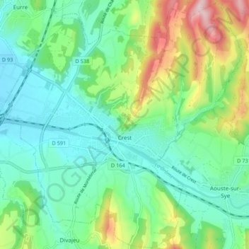
Name: Crest topographic map, elevation, terrain.
Average elevation: 250 m
Minimum elevation: 165 m
Maximum elevation: 467 m
Make a donation
Gear up for your next adventure:
As an Amazon Associate, this site earns from qualifying purchases at no extra cost to you.
Other topographic maps
Click on a map to view its topography, its elevation and its terrain.
Col des Limouches
France > Auvergne-Rhône-Alpes > Drôme > Châteaudouble > Les Limouches
Average elevation: 1,015 m
Make a donation
Gear up for your next adventure:
As an Amazon Associate, this site earns from qualifying purchases at no extra cost to you.
Le Sauze
France > Auvergne-Rhône-Alpes > Drôme > Saint-Christophe-et-le-Laris
Average elevation: 443 m