Geolocate

Chopine topographic map

Click on the map to display elevation.

About this map

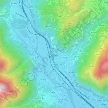
Name: Chopine topographic map, elevation, terrain.

Location: Chopine, Torille, Verrès, Aosta Valley, 11029, Italy (45.64984 7.66451 45.68984 7.70451)

Average elevation: 610 m

Minimum elevation: 352 m

Maximum elevation: 1,476 m

Gear up for your next adventure:

🛶Kayak Dry Bag - Waterproof storage for kayaking adventures
🧥Waterproof Pants - Keep dry during rainy hiking conditions
🥾Approach Boots - Comfortable boots for hiking and climbing approaches
🪑Insulated Seat Pad - Protect your seat from cold rocks and wet logs
👟Sport Hiking Sandals - Breathable footwear for water crossings and camp rest

As an Amazon Associate, this site earns from qualifying purchases at no extra cost to you.