Geolocate

Maricao topographic map

Click on the map to display elevation.

About this map

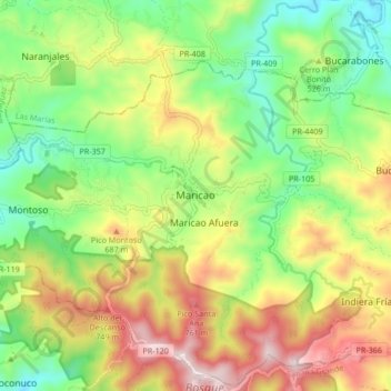
Name: Maricao topographic map, elevation, terrain.

Location: Maricao, Puerto Rico, 00606, United States (18.14076 -67.01979 18.22076 -66.93979)

Average elevation: 488 m

Minimum elevation: 204 m

Maximum elevation: 881 m

Gear up for your next adventure:

💧Reusable Water Bottle - Durable water bottles for hydration on trails
🧶550 Survival Paracord - Versatile utility cord for emergency repairs and rigging
🥾Approach Boots - Comfortable boots for hiking and climbing approaches
💧Hydration Pack - Hands-free hydration system for long hikes
🔦UV Flashlight - Detect minerals or specific insects in the dark

As an Amazon Associate, this site earns from qualifying purchases at no extra cost to you.