Geolocate

Areekode topographic map

Click on the map to display elevation.

About this map

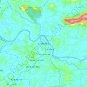
Name: Areekode topographic map, elevation, terrain.

Location: Areekode, Ernad, Malappuram District, Kerala, 673639, India (11.19456 76.00918 11.27456 76.08918)

Average elevation: 43 m

Minimum elevation: -2 m

Maximum elevation: 311 m

Other topographic maps

Click on a map to view its topography, its elevation and its terrain.

Manjeri

India > Kerala > Ernad

Manjeri is located at 11°07′N 76°07′E / 11.12°N 76.12°E / 11.12; 76.12. It has an average elevation of 38 metres (124 feet) from sea level.

Average elevation: 58 m

Alathurpadi

India > Kerala > Ernad > Malappuram

Average elevation: 64 m

Vandoor

India > Kerala > Ernad

Average elevation: 59 m

Irumbuzhi

India > Kerala > Ernad > Malappuram

Average elevation: 43 m

Areekkode

India > Kerala > Ernad

Average elevation: 112 m

Malappuram

India > Kerala > Ernad

Average elevation: 56 m

Malappuram

India > Kerala > Ernad > Malappuram

Average elevation: 62 m

Kavanur

India > Kerala > Ernad > Kavanoor

Average elevation: 42 m

Manjeri

India > Kerala > Ernad

Manjeri is located at 11°07′N 76°07′E / 11.12°N 76.12°E / 11.12; 76.12. It has an average elevation of 38 metres (124 feet) from sea level.

Average elevation: 58 m

Gear up for your next adventure:

🔭Compact Monocular - One-handed bird watching and trail spotting
🥾Trail Running Shoes - Lightweight and durable shoes for trail running
🛏️Sleeping Bag - Warm and compact sleeping bags for outdoor camping
🧤Insulated Winter Gloves - Heavy-duty protection for sub-zero Canadian adventures
🚲Handlebar Phone Mount - View topographic-map.com live while cycling

As an Amazon Associate, this site earns from qualifying purchases at no extra cost to you.