Geolocate

Nangal topographic map

Click on the map to display elevation.

About this map

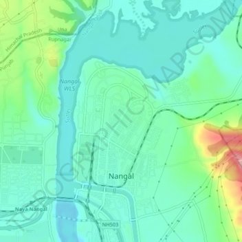
Name: Nangal topographic map, elevation, terrain.

Location: Nangal, Nangal Tahsil, Rupnagar, Punjab, India (31.37407 76.36734 31.40936 76.40039)

Average elevation: 370 m

Minimum elevation: 338 m

Maximum elevation: 470 m

Other topographic maps

Click on a map to view its topography, its elevation and its terrain.

Bhanupali

India > Punjab > Nangal Tahsil

Average elevation: 333 m

Gear up for your next adventure:

🥾Trail Hiking Boots - Supportive boots for rough trails
🧦Hiking Socks - Moisture-wicking and comfortable socks for long hikes
🕶️Polarized Sunglasses - Protect your eyes with durable polarized lenses
🥾Hiking Shorts - Breathable shorts suitable for summer hikes
🛌Down Sleeping Bag - Superior warmth-to-weight ratio for cold nights

As an Amazon Associate, this site earns from qualifying purchases at no extra cost to you.