Geolocate

Carracedo topographic map

Click on the map to display elevation.

About this map

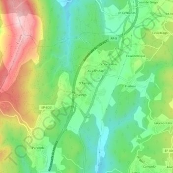
Name: Carracedo topographic map, elevation, terrain.

Location: Carracedo, Caldas de Reis, Caldas, Pontevedra, Galicia, España (42.63673 -8.67268 42.66411 -8.62312)

Average elevation: 171 m

Minimum elevation: 56 m

Maximum elevation: 357 m

Other topographic maps

Click on a map to view its topography, its elevation and its terrain.

Fervenza de Segade

España > Galicia > Caldas > Caldas de Reis

Average elevation: 137 m

Marán

España > Galicia > Caldas > Caldas de Reis

Average elevation: 93 m

Arcos da Condesa

España > Galicia > Caldas > Caldas de Reis

Average elevation: 103 m

Os Barreiros

España > Galicia > Caldas > Caldas de Reis

Average elevation: 86 m

Gear up for your next adventure:

🧭GPS Tracker - Track your location in remote areas safely
🌡️Emergency Mylar Blankets - Compact thermal protection for unexpected nights outdoors
🧦Crew Hiking Socks - Comfortable socks for long-distance hikes
🛶Waterproof Dry Bags - Keep electronics and clothes dry during river crossings
🦟Insect Repellent - Keep mosquitoes and black flies away in wooded areas

As an Amazon Associate, this site earns from qualifying purchases at no extra cost to you.